Workshop Sarno Plain
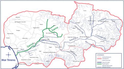
THE CATCHMENT AREA OF SARNO RIVER
Carlo Gasparrini
Il sito/The site
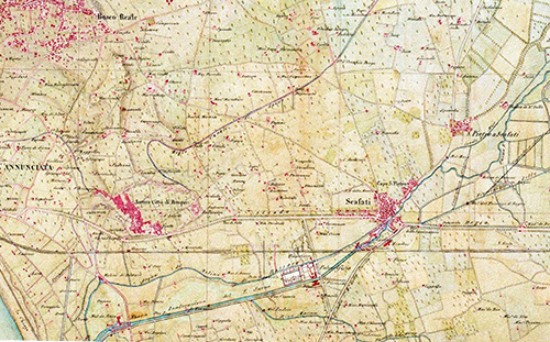
The Sarno river is in the Campania region of Italy and is 24 km long. It rises from the slopes of Mt. Sarno near the town that also bears that name and it grow from various sources.The main tributaries are: Santa Maria la foce, Mercato-Palazzo, Santa Marina di Lavorate, Cerola and San Mauro; Estuary is located in Torre Annunziata town, overlooking the Bay of Naples. The hydrographic structure is composed by a main course (Sarno river) and a system of secondary tributaries and canals: Cavaiola, Solofrana, Alveo Comune Nocerino and Calvagnola. A secondary system of tributaries is composed by: rio Lauro, rio Lavinaro and rio Lavinaio. The hydrological system as a whole covers a linear length of about 1600 km.
I River Sarno basin includes 35 municipalities as follows: Angri, Boscoreale, Boscotrecase, Bracigliano,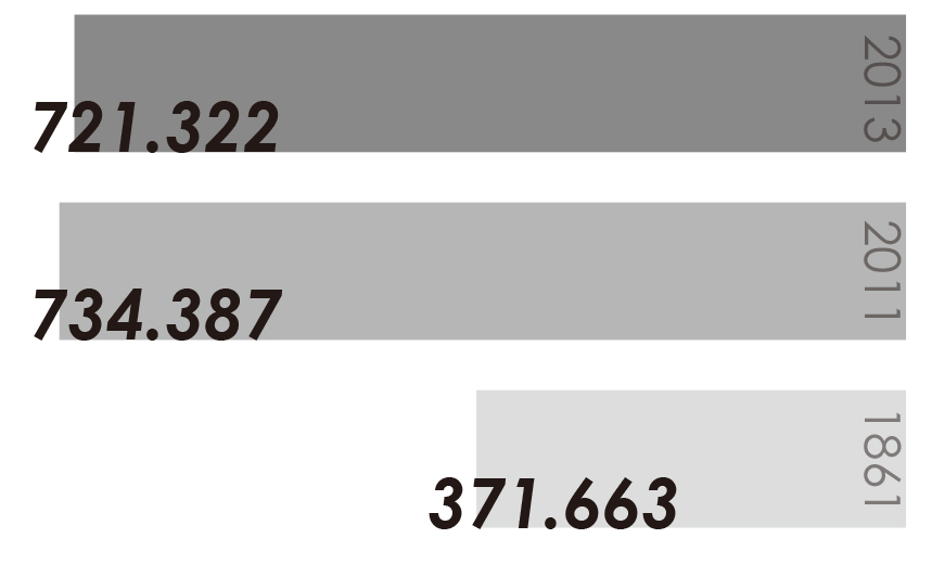 Calvanico, Castel S. Giorgio, Castellammare di Stabia, Cava de’ Tirreni, Corbara, Fisciano, Forino, Lettere, Mercato S. Severino, Montoro, Nocera Inferiore, Nocera Superiore, Ottaviano, Pagani, Poggiomarino, Pompei, Roccapiemonte, S. Antonio Abate, S. Egidio del monte Albino, S. Giuseppe vesuviano, S. Maria la carità, S. Marzano sul, Sarno, S. Valentino torio, Sarno, Scafati, Siano, Solofra, Striano, Terzigno, Torre Annunziata, Trecase, belonging to the provinces of Napoli, Salerno and Avellino. The population currently residing in the whole area of the basin is 721,322 inhabitants, according to the last 2013 ISTAT census. The most populous town is Castellammare di Stabia, with 66,232 inhabitants and an average density of 3,752.5 inhabitants / km²; less populous town is Calvanico, with 1,574 inhabitants and an average density of 105.3 inhabitants / km².
I The first settlements in the area were built in the sixth century BC, when a population of Greek origin, the Sarrasti (from the name of Sarno river, originally called Sarro) came from the Peloponnese lands to the Vesuvius coast. Traces of these settlements have been found in the archaeological site of Poggiomarino-Longola. The Romans, as is well known, lived these territories, as witnessed by the archaeological sites of Pompeii, Stabiae and Nucera Alfaterna. In the Middle-Age period, the area had a general decline phase with a settlement relocation from downstream lands along the river to the upper lands on the surrounding hills. Consequently there was a partial dereliction of land along the river.
In the early 1300, the first industrial settlement arose. It was Solofra tanning industry for leather treatment, using Solofrana creek water. Since only from early 1500 the situation changed. Urban settlements started to grow again, and as consequence, an economic development occurred. The progress, however was not supported by the road and infrastructural network that was really poor and barely accessible. Just in this period some important and critical events for the Agro Nocerino Sarnese territory occurred.
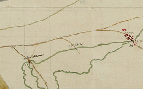
I At the end of 1500, the Count of Sarno, Muzio Tuttavilla, decided to pick up the northernmost source and build a canal to direct Sarno water to Torre Annunziata, where a system of mills was built. In the course of following centuries mills gave energy for the milling of wheat, textile factories and arms factories. Several other mills were built along the main course of the river or along the secondary canals, to exploit water as a driving force.
I Between 1600 and 1700, the Count of Celano, with same purpose, ordered to build three bulkheads and later a barrage close to Scafati, to divert the river and feed the Bottaro channel. Since then the modification of natural water courses prevented the river navigability and caused the extinction of numerous plant and animal species. All of hydrographic system, which until now had been preserved in its integrity and naturalness, was compromised. The fertile agricultural lands of Sarno plain were gradually turning into marshland and devastated by frequent flooding. Several works were done to overcome the problem and an artificial canal system was built to drain the excess water, limit the effects of flooding, and at the same time be functional to irrigate fields.
I In 1800, under the house of Bourbons reign, reclamation works for the Sarno river started. This was done by adjusting the hydrographic network and then increasingly compromising the river ecosystem. This practice increased over years and today the river system and canals are almost all artificially built. In the same century textile industrial sites were built and marked the turning point of industrial and economic development of the area. The water plays an increasingly important role in the production chain. It is used not only as a driving force but also as a tool for material processing and as a means to ward the production scraps. Towards the end of the century the infrastructure network has been enhanced, it became a support to all the industrial companies already acquired over the century and the union between industry and agriculture took place.
I In 1882 the Cirio Industry settled in Pagani with a processing plant of agricultural products thus canning industry development began. This kind of industry represented and still today represent the prevailing activity of the area (the ISTAT data coming from “Census of Agriculture” reveal it). The production chain for canning industry is complete, from intensive agriculture to industrial processing of products up to canning.
I Some example data Industrial production of tomatoes in Campania:
_5.365 hectares
_589,2 Quintals / hectare
_3.131.240 Tons / year
I From the second half of the ‘900 territorial setting start to consolidate, along major roads and railways some of the largest industrial production are located, relying on location and resource advantages. Consequently, the residential building pattern is going to saturate spaces close to infrastructures, creating a dense, continuous but fragmented land uses over the years. The housing situation changes radically according to the new population demands, the majority of manpower has gone from carrying out activities as farm laborer mainly to construction worker.
I The new development does not follow any rules and generates environmental and social discontinuity instead. In addition to agriculture, food and canning industry other production chains are present in this area. Chemical, pharmaceutical and manufacturing (textiles, paper mills, tanning, shipyards) are industries of great relevance that make this area a point of reference for Southern Italy. All industrial plants have a strong impact on environment spreading large amounts of toxic substances in air and water, most of them are harmful to humans, fauna and flora. Through illegal dumping, production scraps without any prior treatment drain in the streams. It is required that all manufacturing sites should establish special sewage plant treating waste water before entering it in the river network. In turn these waters should be further purified, as in the collecting system are also spilled neighboring communities sewage that often have incomplete sewerage. It thus generates a chain of pollutants that affect the environmental system and rivers in a particularly critical way. Hydrographic structure of Sarno river is then used first as a driving force, then as open sewer.
I Another serious problem is the massive uptake of water from underground aquifers through wells. This practice took place either legally or illegally. Since 1800, during a strong prohibition period, peasants began to withdraw water illegally from wells to avoid the tax payment to landowner. The spread of this practice does not allowed to carry out a census of drawing of water and we can only make an estimation that reveal about 10,000 illegal wells spread over the territory. The consequence is aquifer depletion and whole upheaval of natural water cycle.
1795 |
1838 |
1980 |
2010 |

Introduction: Sarno Plain
Coordinator: Vito CAPPIELLO
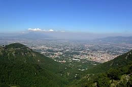
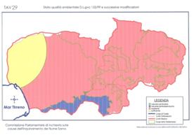
Sarno River Basin is located to the south of the Somma-Vesuvius volcanic complex in south Italy. It covers an area of about 450 kmq and is drained by the Sarno river (a short watercourse of about 24 km) and its tributaries: Cavaiola and Solofrana. In the south and in the east it is flanked by the Apennine mountain range and in the west opens to the Tyrrhenian Sea near the cliff of Rovigliano (also called Rock of Hercules), between two cities: Castellammare di Stabia and Torre Annunziata.
Il bacino del fiume Sarno è ubicato a sud del complesso vulcanico Monte Somma-Vesuvio, nell’Italia meridionale.
Ricopre una superficie di circa 450 kmq su cui scorrono il corso principale, il fiume Sarno (lungo circa 24 km) e i suoi affluenti: Cavaiola e Solofrana.
A sud e ad est è costeggiata dall’Appennino e ad ovest si apre verso il Mar Mediterraneo nei pressi dello scoglio di Rovigliano (chiamato anche Rocce di Ercole), tra due città: Castellammare di Stabia e Torre Annunziata.

The initial stretch of the Sarno river, at one time, was fed by numerous springs, but from the middle of the last century, the main courses were used to power up the Campano Aqueduct.
The Sarno river is still powered by waters of three sources: the Outfall, at north-west of the town of Sarno and from which also originated the Canal “Conte di Sarno”. The second source, Palazzo, is located behind the town, and the third, San Marino, near the municipality of Lavorate.
Il tratto iniziale del fiume Sarno un tempo era alimentato da numerose sorgenti, ma dalla metà dell’ultimo secolo il corso principale è stato usato dall’acquedotto Campano per l’approvvigionamento idrico. Il Sarno è ancora alimentato dall’acqua di tre sorgenti: la Foce, a nord ovest della città di Sarno da cui è anche originato il canale “Conte di Sarno”. La seconda fonte, Palazzo, è ubicata nel centro della città, e la terza, San Marino, in località San Marino.
The area of Sarno River Basin has been densely populated and urbanized since the Middle Bronze Age, as testified by the presence of numerous archeological sites, including ancient Pompeii town.
The Sarno River has been used as an active, navigable waterway since ancient times, thanks to capacity and regularity of its flow. Also, thanks to the reliable navigability of much of its course, the use of its waters for irrigating the surrounding lands, made fertile by the volcanic material emitted long before by Vesuvius (it also modified the original course of the river), and the vast marshy areas at the level of its mount, the Sarno was extremely important for the economic life of this part of Campania region.
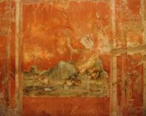
Indeed it was personified and honored almost as a divinity. Vesuvian wall painting contain depictions in which the Sarno assumes the usual aspect of a river god.
L’area del bacino del fiume Sarno è stata densamente popolata e urbanizzata fin dalla prima metà dell’età del Bronzo, come testimonia la presenza di numerosi siti archeologici, tra cui l’antica città di Pompei.
Il fiume Sarno è stato usato fin dai tempi antichi come via navigabile, grazie alla capacità e regolarità del suo corso. Inoltre, grazie alla affidabile navigabilità di gran parte del suo percorso, all’uso delle acque per irrigare i campi circostanti resi fertili dai materiali vulcanici emessi tempo prima dal Vesuvio (che ha modificato anche il corso del fiume), e per la vasta area paludosa all’altezza della sua foce, il Sarno è stato estremamente importante per la vita economica di questa parte della regione Campania.
Infatti, il fiume Sarno era impersonificato e adorato come una divinità. Pitture murali contengono rappresentazioni in cui il Sarno assume l’aspetto usuale di un dio fluviale.
Threats and weaknesses
Minacce e punti di debolezza
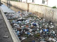
Currently, the Sarno river, still partially used for irrigation, is affected by an extreme environmental degradation as a result of uncontrolled outflow of industrial waste.
Pollution is commonly attributed to the waste product of the tomato industries (108 settled mainly along Sarno river), to the chemical processing of animal skin (184 leather tanneries principally along Solofrana tributary) and to the pharmaceutical industry represented principally by Novartis Pharma one of the largest and most important facilities in the world.
Many other small and medium factories are also present in the area.
The situation is worsening by large-scale dumping of untreated agricultural, urban and other industrial wastes into the river.
Attualmente, il fiume Sarno, ancora parzialmente usato per l’irrigazione, è interessato da un forte degrado ambientale risultato di scarichi industriali incontrollati.
L’inquinamento è generalmente attribuito agli scarti di lavorazione delle industrie di pomodori (108 sono ubicate principalmente lungo il fiume Sarno), ai processi chimici di lavorazione delle pelli animali (184 concerie di pelli sono localizzate prevalentemente lungo un affluente del Sarno, la Solofrana) e alla industria farmaceutica rappresentata dalla Novartis Pharma una delle più grandi e importanti strutture nel mondo.
Inoltre, nell’area sono presenti molte altre piccole e medie industrie.
La situazione sta peggiorando su larga scala per lo scarico nel fiume di rifiuti agricoli, urbani e industriali non trattati.
This area is also plagued by frequent flooding and mudslides; the worst event in the past was occurred in 1998 killing 137 people. After this event it were built risk mitigation measures.
The combination of high-density population and the presence of highly polluting economic activities has given rise to an extremely precarious environmental situation in this area, which represents an insurmountable obstacle in the way of all prospects of growth. In fact, the serious state of environmental decline, as well as making massive redevelopment measures necessary, suffocates the natural and historical-archaeological wealth of this area, making socio-economic development impossible.
Quest’area è anche afflitta da frequenti inondazioni e frane; il peggior evento nel passato si è verificato nel 1998 comportando 137 vittime. Dopo questo evento sono state costruiti interventi di mitigazione del rischio.
La combinazione di un’alta densità di popolazione e la presenza di attività economiche altamente inquinanti ha dato luogo ad una situazione ambientale estremamente precaria, che rappresenta un insormontabile ostacolo sulla strada di ogni prospettiva di sviluppo. Infatti, il serio stato di declino ambientale oltre a rendere necessarie importanti misure di risanamento, soffoca la ricchezza naturale e storico-archeologica di questa area, rendendo impossibile lo sviluppo socio economico.
The decontamination of the river Sarno, which began with the Special Project for the reclamation of the entire Bay of Naples in 1973, is a story, which, after over thirty years, has not yet reached a conclusion, despite the ongoing attention it receives from institutions.
With the Prime Ministerial Decree of 14 April 1995, a state of emergency was declared with regard to the environmental and socio-economic situation in the drainage basin of the Sarno. Initially, the President of the Campania Regional Authority, Antonio Bassolino, was appointed as Emergency Commissioner, and later, with the Order no. 3270 of 12 March 2003, “Further Provisions to tackle the socio-economic-environmental emergency in the drainage basin of the River Sarno”, the office of emergency commissioner was passed to General Roberto Jucci.
The tasks entrusted to the new Commissioner involved the construction of a new purification system for the Sarno, the design and realization of sewer systems for the entire basin, the project and relative dredging and decontamination of the sediment of the river itself, its main tributaries and canals, as well as the implementation of specific measures for the companies and industries in the area, to reduce the negative impact on the environment.
La decontaminazione del fiume Sarno, che è iniziata con il Progetto speciale per la riqualificazione dell’intero Golfo di Napoli nel 1973, è una storia che dopo oltre 30 anni non vede ancora una conclusione, nonostante l’attenzione costante che riceve dalle istituzioni.
Con il Decreto Ministeriale del 14 Aprile 1995 fu dichiarato lo stato di emergenza in riferimento alla situazione ambientale e socio-economica nel Bacino del Sarno. Inizialmente, fu nominato Commissario dell’Emergenza il Presidente della Regione Campania, Antonio Bassolino, e più tardi, con l’Ordinanza n.3270 del 12 Marzo 2003, “Ulteriori disposizioni per affrontare l'emergenza socio-economico-ambientale nel bacino idrografico del fiume Sarno”, l’ufficio del commissariamento fu trasferito al Generale Roberto Jucci.
I compiti affidati al nuovo Commissario hanno riguardato la costruzione di un nuovo sistema di depurazione per il Sarno, la progettazione e realizzazione di sistemi fognari per l'intero bacino, il progetto e relativo dragaggio e bonifica dei sedimenti del fiume stesso, i suoi principali affluenti e canali, nonché l'attuazione di misure specifiche per le aziende e per le industrie della zona, per ridurre l'impatto negativo sull'ambiente.
In the 2014 the European Commission has approved an investment of more than €150 million from the European Regional Development Fund (ERDF) to restore and rehabilitate the environment of the Sarno river basin. This project aims at preserving the long-term safety and health of the 900 000 people living in this area who have been regularly heavily hit by floods since twenty years, causing deaths and economic losses.
The project involves the following interventions:
- Rehabilitation of interventions along the river's banks of the Sarno river and the canal network and construction of a second river outlet;
- Construction and hydraulic works;
- Constructions of storage reservoirs and adaptation of the existing ones;
- Construction of flood-control areas;
- Interventions in monitoring and the civil protection.
Citizens and environmental associations are worried because they dread that this project could have important environmental impacts, worsening the bad conditions of territory.
Nel 2014 la Commissione Europea ha approvato un investimento di più di 150milioni di euro a valere sul Fondo Europeo per lo Sviluppo Regionale (FESR) per ripristinare e riqualificare l’ambiente del bacino del fiume Sarno. Questo progetto ha lo scopo di preservare la sicurezza a lungo termine e la salute di 900mila persone che vivono in questa area e che da vent’anni sono regolarmente e pesantemente colpiti da inondazioni, provocando vittime e perdite economiche.
Il progetto comprende i seguenti interventi:
- Interventi di riqualificazione lungo le sponde del fiume Sarno e della rete di canali e costruzione di una seconda foce del fiume;
- Lavori idraulici e di opere relative;
- Costruzione di bacini di stoccaggio e adattamento di quelli esistenti;
- Costruzione di aree ad inondazione controllata;
- Interventi di monitoraggio e di protezione civile.
Cittadini e associazioni ambientaliste sono preoccupati perché temono che questo progetto potrebbe avere importanti impatti ambientali, peggiorando le cattive condizioni del territorio.
Strengths and opportunities
Punti di forza e opportunità
History
The Sarno River Basin is a very complex area where history, natural elements, landscape, and anthropic factors combine and affect themselves. It is possible to define many routes which link up different historical places discovering a particular age of this territory.
For example, in the study area there are ruins of roman aqueduct, but also buildings of XVIII century. This territory tells about itself, tells about ancient periods until nowadays, visitor has to only choose the route’s direction.
Storia
Il bacino del fiume Sarno è un’area molto complessa dove storia, elementi naturali, paesaggio e fattori antropici si combinano e si influenzano. È possibile definire molti percorsi che collegano i vari posti di interesse storico scoprendo un particolare periodo di questo territorio. Per esempio, nell’area di studio ci sono rovine di un acquedotto romano, ma anche edifici del XVIII secolo. Questo territorio racconta se stesso, di epoche antiche fino ad oggi, il visitatore deve solo scegliere la direzione del percorso.
Geomorphology
This area is strongly characterized by geomorphology: the carbonate massif allows the surface and underground water circulation. The Sarno valley is located in the southern Tyrrenian continental margin of Campania region which owes its complex stratigraphic architecture to the interaction between volcanic and sedimentary processes during the Late Quaternary. So, seismic and volcanic activities have defined the current asset: level, fertile and permeable soils. Vesuvius is the key of geomorphology landscape.
Geomorfologia
Quest’area è fortemente caratterizzata dalla geomorfologia: il massiccio carbonatico permette la circolazione superficiale e sotterranea delle acque. La valle del Sarno è ubicata nel margine continentale meridionale Tirrenico della regione Campania che deve la sua complessa architettura stratigrafica all’interazione tra i processi vulcanici e sedimentari avvenuti nel tardo Quaternario. Quindi, attività sismiche e vulcaniche hanno definito l’attuale assetto: terreni pianeggianti, fertili e permeabili. Il Vesuvio è la chiave del paesaggio geomorfologico.
Natural resources
The environmental crisis is not the only condition of Sarno River Basin. There are many unknown places where it is possible discovering the natural ecosystems of this river.
These places are mainly located near springs of Sarno River.
Risorse natuali
La crisi ambientale non è l’unica condizione del bacino del fiume Sarno. Ci sono molti posti sconosciuti dove è possibile conoscere gli ecosistemi naturali di questo fiume. Questi posti sono ubicati principalmente in prossimità delle sorgenti del fiume Sarno.
Anthropic activities
The main economic activity in the Sarno valley was been the agriculture. There are many excellent products that are exported worldwide too. Among these, the most important is a kind of tomato called “San Marzano”. However, above kind and quality of each product, it is important to consider culture and traditions linked to agriculture in the Sarno Valley.
Some music and songs which farmers used to sing during the work are still played during traditional festivities. The most popular work song is “tammorriata” which was played by castanets and tambourines.
Also, the use of river’s water has implicated the construction of mills and hydraulic systems to irrigate fields or to restore these ones. Currently, only one of more than 30 mills is known and there is located in the historical center of the Sarno town.
Attività antropiche
La principale attività antropica nella valle del Sarno è stata l’agricoltura. Ci sono molti prodotti eccellenti che sono anche esportati in tutto il mondo. Tra questi, il più importante è un tipo di pomodoro chiamato “San Marzano”. Tuttavia oltre al tipo e alla qualità di ciascun prodotto, è importante considerare la cultura e le tradizioni connesse all’agricoltura nella valle del Sarno.
Alcune musiche e canzoni che i contadini cantavano durante il lavoro sono ancora cantate durante le feste tradizionali. La canzone di lavoro più popolare è la “tammorriata” che è suonata con nacchere e tamburelli.
Inoltre, l’uso dell’acqua del fiume ha comportato la costruzione di mulini e sistemi idraulici per irrigare i campi o bonificare gli stessi. Attualmente è noto solo uno dei più di 30 mulini ed è ubicato nel centro storico di Sarno.
Workshop places
I luoghi del workshop
The workshop focuses on three specific areas in the municipality of Sarno:
- Muro Rotto tank area;
- 5 Sensi Park and Linear River Park area;
- Historic Center of the town.
These includes all aspects discussed before, as It will be better explained below.
Il workshop focalizza l’attenzione su tre aree specifiche nel territorio della città di Sarno:
- L’area della vasca Muro rotto;
- Il Parco 5 sensi e il parco fluviale lineare;
- Il centro storico della città.
Queste includono tutti gli aspetti discussi prima, come sarà meglio spiegato qui di seguito.
Muro Rotto Tank area is located in the northern suburbs of Sarno town.
There is a hydraulic intervention made by Consortium of Drainage Sarno District to mitigate flooding risk. During the escavation’s phase, ancient tombs were been found, and one of these was been called “Warrior’s Tomb” based on the painting found inside.
The painting was taken and moved to the local museum, while the other tombs buried again there involving changes to the initial project of the tank.
From this place it is possible to have a view on Vesuvius, while changing the point of view to the Sarno montain there is an inactive and abandoned quarry.
Currently, this area is totally unknown and adandoned.
L’area della vasca Muro Rotto è ubicata nella periferia nord della città di Sarno.
In quest’area vi è un intervento idraulico effettuato dal Consorzio di Bonifica Comprensorio Sarno per mitigare il rischio di inondazioni. Durante la fase di scavo sono state trovate delle tombe antiche e una di queste è stata chiamata “Tomba del guerriero” per i dipinti trovati all’interno.
Le pitture murarie sono state rimosse e portate presso il museo locale, mentre le altre tombe sono state reinterrate comportando una modifica al progetto iniziale della vasca.
Da questo posto è possibile avere una vista del Vesuvio, mentre cambiando il punto di vista verso la montagna di Sarno c’è una cava inattiva e abbandonata.
Attualmente l’area è totalmente sconosciuta e abbandonata.
Less than a kilometer towards the center of Sarno town, there is an other suburbs unit, more different than last, but potentially complementary.
This place, called “Foce”, includes a human activities (aqueduct, one of the most important in the South Italy), degraded connection areas and two river parks.
The first is known as “5 Sensi Park”, It is managed by a cooperative and generally is closed. The second one was made by Consortium of Drainage Sarno District last year and It is always accessible, however people often leave rubbish there.
The river is the first of three which currently make the Sarno River. This is called “Rio Foce”. This site includes a roman amphitheater and an ancient Sanctuary.
Meno di un chilometro verso il centro della città di Sarno, c’è un’altra unità periferica, molto differente dalla precedente, ma potenzialmente complementare.
Questo posto, chiamato “Foce”, include un’attività antropica (l’acquedotto, uno dei più importanti nell’Italia meridionale), aree di connessione degradate e due parchi fluviali.
Il primo è noto come “Parco 5 Sensi”, è gestito da una cooperativa ed è generalmente chiuso.
Il secondo è stato realizzato l’anno scorso dal Consorzio di Bonifica Comprensorio Sarno ed è sempre aperto, tuttavia le persone spesso vi abbandonano rifiuti.
Il fiume è il primo delle tre che attualmente formano il fiume Sarno. Questo è chiamato “Rio Foce”.
Questo sito include un anfiteatro romano e un antico santuario.
The last unit, but not least, is the center of the Sarno town, where the second spring which creates the Sarno River, arises.
It is called Rio Palazzo and its distance from Rio Foce is about 2 kilometers.
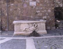
In the center of the town there are many historical buildings, abandoned ancient industries at now, and a singular hamlet located on the slopes below the castle.
This hamlet called “Borgo San Matteo” (Saint Matthew Hamlet).
Also, there is an aqueduct that is currently closed.
During the summer some associations organize events in the castle, but generally the center is not valorized.
In different locations of the town, as described in the book “Aqueduct Claudio”, available on dropbox, there are roman aqueducts' ruins.
It was chosen to not include here the third spring, called Rio San Marino, because this area is mainly agrarian and many farmers take care of it.
The most important challenge is the case study areas which are complex and also representative of a situation widespread in almost all the cities included in the Sarno River Basin.
The survey will be developed in the same order which was used here to present the places.
L’ultima unità, ma non meno importante, è il centro della città di Sarno, dove è presente la seconda sorgente che da vita al fiume Sarno. È chiamata Rio Palazzo e la sua distanza dal Rio Foce è di circa 2 km.
Nel centro della città ci sono molti edifici storici, storiche industrie abbandonate e un particolare borgo ubicato sul versante sotto il castello. Questo borgo è chiamato “Borgo di San Matteo”.
Inoltre vi è un acquedotto attualmente chiuso.
Durante l’estate alcune associazioni organizzano eventi nel castello, ma generalmente il centro non è valorizzato.
In vari posti della città, come descritto nel libro “Acquedotto Claudio” messo a disposizione nella cartella dropbox, ci sono rovine di un acquedotto romano.
È stato scelto di non includere la terza sorgente chiamata “Rio San Marino” perché quest’area è principalmente agricola e molti agricoltori se ne prendono cura.
La sfida più importante è le aree scelte come caso studio che sono complesse e rappresentative di situazioni diffuse in quasi tutte le città comprese nel bacino del fiume Sarno.
Workshop goals
Obiettivi del workshop
The activities will focus on the area located between the historical center of the Sarno town and a system of abandoned quarries.
Overall the area includes fascinating units which currently are neither linked nor valorized referring to a landscaping and environmental point of view.
The main elements, different for typology and quality, which can be identified are:
- Historical center characterized by monumental and architectural attributes;
- Incomplete and degraded linear river park system by the side of the first course which creates the Sarno River;
- 5 Sensi Park system and the close areas which include ruins of roman aqueduct and other archeological heritages;
- System of spread farmland;
- Area in which they are closed quarries and deteriorate buildings;
- Muro Rotto tank where was found “Warrior’s tomb” (currently located in the museum);
- A system of tombs which are interred again.
The Workshop was born to be strongly characterized by an interdisciplinary approach. The main aspiration, starting from the awesomeness given by Muro Rotto tank and archeological heritage, is to discover design solutions aimed to:
- Valorize the suggestive Muro Rotto tank area taking into account the view on Vesuvius;
- Reuse the abandoned quarries and related buildings with an artistic and practical approach;
- Retrain 5 Sensi Park area;
- Retrain and complete the Linear River Park of “Foce Sarno”;
- Reuse the existing farmland;
- Valorize the historical heritage in the center of Sarno town;
- Define connection between these system to ensure spatial continuity and reconnection with agricultural landscape. For example: cyclo-pedestrian routes with identification of parking area and viewpoints.
Le attività si focalizzeranno sull’area compresa tra il centro storico della città di Sarno e un sistema di cave abbandonate.
Complessivamente l’area comprende un sistema interessante, ma allo stato attuale non connesso e non valorizzato dal punto di vista paesaggistico ed ambientale, di luoghi di varia tipologia e qualità:
- il centro storico, con qualità monumentali ed architettoniche;
- il sistema del parco fluviale lineare, parzialmente attuato, ma in stato di degrado, lungo uno dei corsi di acqua (Foce Sarno) che alimentano il Sarno
- il sistema del “parco dei cinque sensi” e le sue aree contermini, contenenti anche resti di un antico acquedotto romano;
- il sistema diffuso dei campi agricoli;
- l’area delle cave dismesse, con edifici abbandonati;
- la vasca di bonifica “muro rotto”, dove, durante la sua costruzione è stata rinvenuta la così detta “tomba del guerriero”, attualmente delocalizzata nel museo di Sarno;
- un sistema di tombe contermini, oggi rinterrate.
Il workshop, nell’ottica di un progetto fortemente interdisciplinare, partendo dalla suggestione data proprio dalla vasca “muro rotto” e dai resti archeologici, esplorerà soluzioni progettuali tendenti a:
- una valorizzazione evocativa dell’area della vasca “muro rotto”, che tenga conto anche della sua visuale sul monte Somma;
- riuso artistico e funzionale del sistema delle cave dismesse e dei suoi manufatti abbandonati;
- riqualificazione dell’area del “parco dei cinque sensi”;
- riqualificazione ed estensione del parco fluviale lineare “Foce Sarno”;
- riuso del sistema agricolo esistente;
- valorizzazione dei beni monumentali del centro storico;
- individuazione di un sistema di percorrenze di continuità fra i vari elementi, di tipo ciclo-pedonale, con
- individuazione di aree sosta, belvedere e riconnessione con il paesaggio agrario.
_______________________________________________________________________________________
Detailed Programme of 29/09/2015
8.00 Departure From Naples (Palazzo Gravina) to Sarno town
8.50 Arrival at Sarno in the Muro Rotto tank area
9.00 Guided tour with the General Director of Consortium of Drainage Sarno district, M.Eng. Luigi Daniele
10.00 Guided tour of 5 Sensi Park and Linear River Park
10.45 Guided tour in the historical center of Sarno town (with coffee break, only 15 minutes)
11.45 Departure to Nocera Superiore town (Sa)
12.10 Arrival at Villa de Ruggiero - meeting with local administrators and stakeholders
12.40 Departure to Nocera Inferiore town
13.00 Arrival at the head office of Consortium of Drainage Sarno district – Institutional Greetings by Commissary Dr. Antonio Setaro
13.30 Lunch
15.00 Workshop
20.30 Departure to Naples
21.15 Arrival at Naples (Palazzo Gravina)
![]() THE CATCHMENT AREA OF SARNO RIVER
THE CATCHMENT AREA OF SARNO RIVER
![]() Introduction: Sarno Plain
Introduction: Sarno Plain
![]() Detailed Programme of 29/09/2015
Detailed Programme of 29/09/2015
Useful Link: http://www.adbcampaniacentrale2.it/